Has Recent Geothermal Energy Production Been a Factor in the August 2012 Earthquake Swarm North of Brawley, CA?
This informal web site was created to share comments about the nature of the August 26, 2012 earthquakes sequence that occurred just north of Brawley, CA. The site was first constructed on Sept. 4, 2012 and updated on Sept. 5. It is not intended for public use or view, but for scientific discussion only.
The above is a quote from C. D. Klose (citation) pointing out that the Salton Sea geothermal developments may be one of the new hot spots for triggering a major earthquake, likely on the Imperial or San Andreas fault zones.
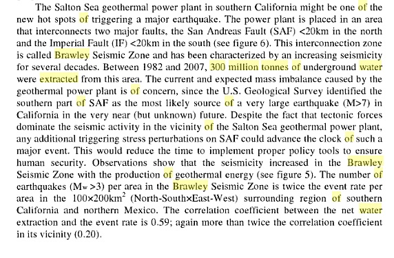
The figure above shows earthquakes in August 2012, with the majority occurring in the 48 hours period from Aug. 25 to Aug. 27. Location of the Ormat North Brawley geothermal power plant is shown by the black rectangle north of Brawley in this figure and by the 'P' in the lead in illustration.
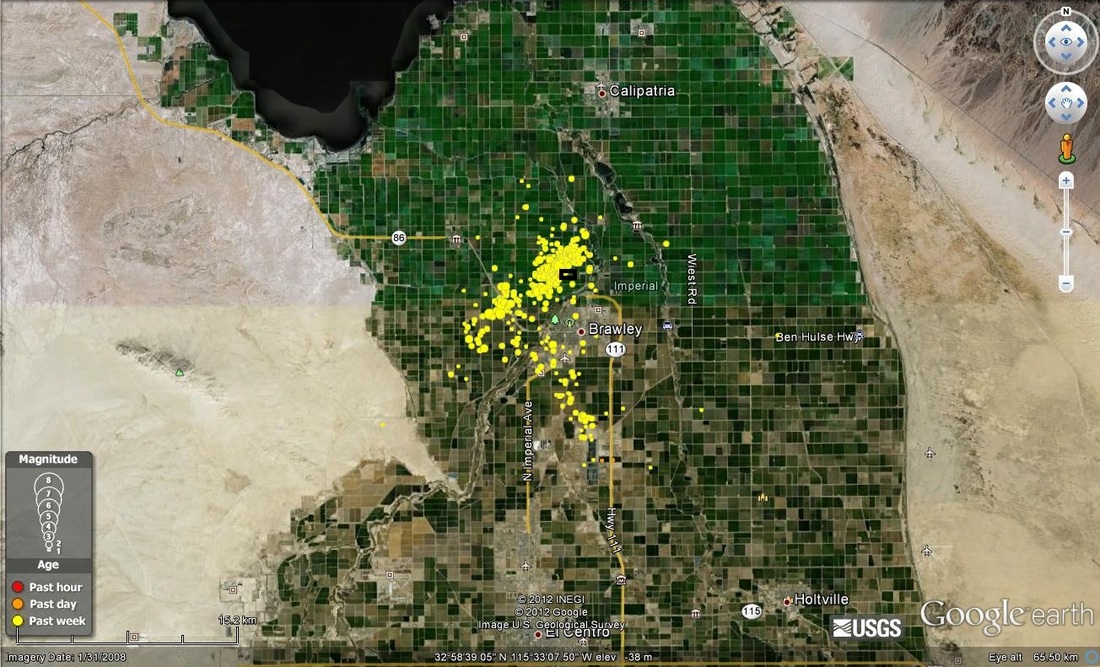
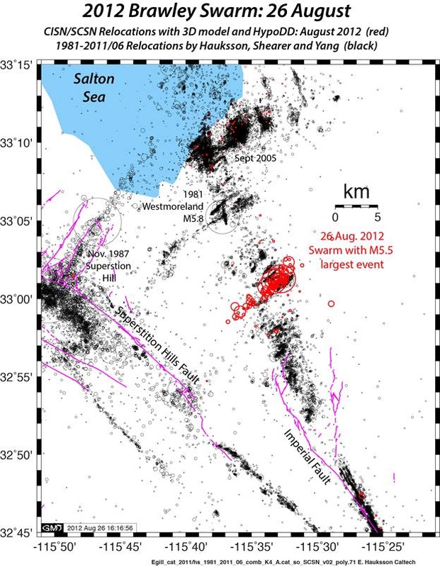
August 26, 2012 swarm on the stepover part of the Brawley fault zone reproduced from scsn.org. Hudnut et al (1989) outlined a sequence of northwestward stepping earthquakes (1979, 1981, and 1987) which ruptured a set of left-lateral, northeast-trending stepover faults. The current swarm follows such a stepover between the extension of the Imperial fault and NW trending spurs of the Brawley fault zone. This is the area where current geothermal develoment has been proceding since 2009, as shown in the well location plot below.
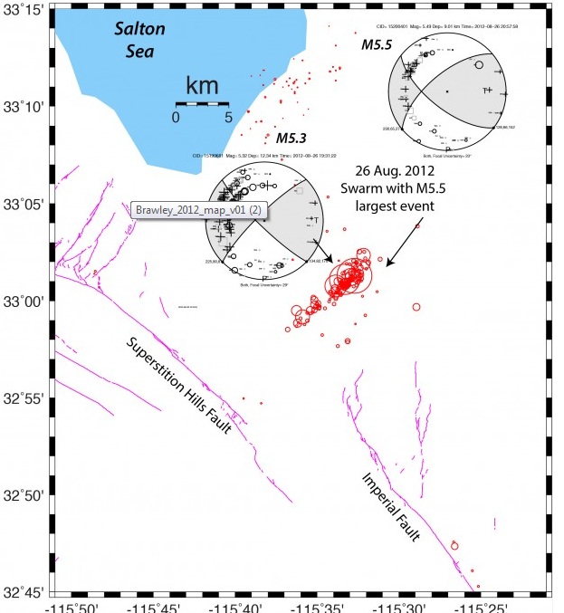
In the map above, the California Dept. of Conservation map of wells in the Brawley area are shown by triangles, with active wells indicated in red. The new Ormat facility north of Brawley is shown in outline by the black rectangle.
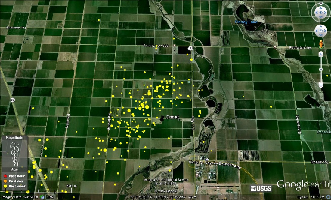
Earthquakes for 8/20/2012 to 8/27/2012 in the Brawley stepover zone. The Ormat power plant is noted by the black pin.
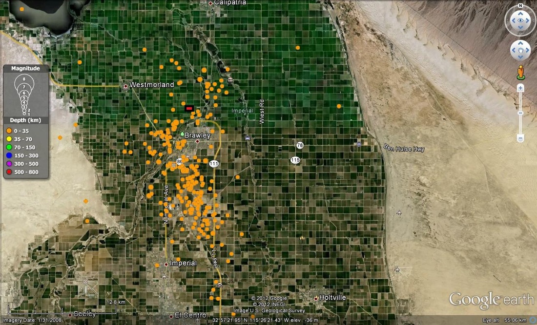
Plot above represents overall earthquake patterns in the southern Salton Sea area, figure copied from the SCSN web site.
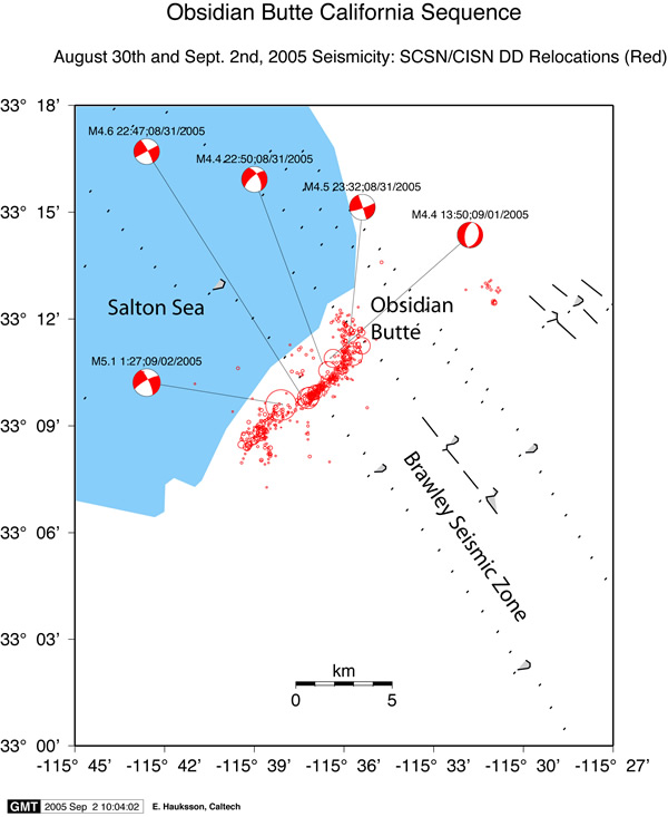
Details of the 2005 earthquake sequence located on the south Salton sea stepover zone containing several young intrusives and geothermal wells.
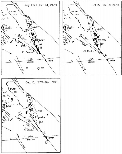
The plot above shows events for the 1979 Brawley sequence related to the M6.4 Imperial fault quake. A M5.4 aftershock occurred just south of Brawley. Several time plots of this episode are shown below from 7/77 to 12/83. The west side of the Brawley fault zone is most active and then the stepover zone picks up activity at some point. The location of the stepover events in 1979 was south of the location of the Ormat plant and just north of the edge of the city of Brawley. This suggests that the stepover fault zone occupies a basement section of about 5 km width.
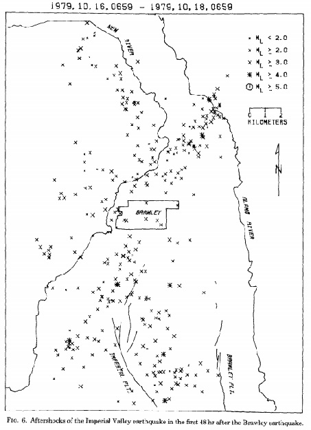
A more detailed plot for 48 hours following the 1979 (from Heaton et al) Imperial quake shown above indicated that seimicity in the stepover zone north of Brawley focuses much of the activity where most of the active well for the Ormat plant are currently located. This data suggests that the extensional zone in the stepover north of Brawley is primary to the geothermal system and to its expression in earthquake patterns.
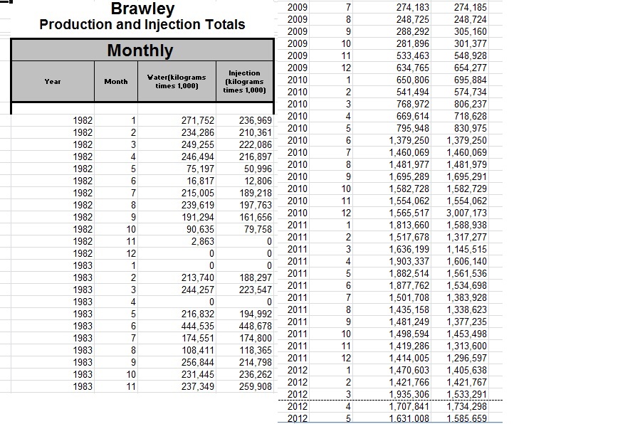
The North Brawley field was expanded and redeveloped (original developer was CalEnergy) by Ormat, resulting in a tenfold increase in production starting in late 2009 after a multi year hiatus. In the data shown in the table above, the hiatus is not indicated. There are some questions regarding the data that need to be answered. Why in Dec. 2010 was there a two fold increase in injection versus production? Conceivably stored water was reinjected this month from storage ponds?
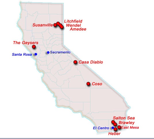
The tenfold increase in production/injection data at Brawley, is dramatic, but the production at the Salton, East Mesa and Heber fields is much larger (5-8 times) than at Brawley. These production rates can be viewed at the California Conservation GIS page: http://www.conservation.ca.gov/dog/geothermal/manual/Pages/production.aspx
In our view it is likely that the North Brawley field is critical in the stepover area in which it is located. Whether geothermal production triggering of earthquakes on this stepover is more crucial in triggering a San Andreas event than stimulated earthquakes in the Salton Sea south field or the East Mesa or Heber fields is debatible, but it may be possible to better understand the role of geothermal production in triggering earthquake swarms by study of this most recent swarm.

Spreading ridge structure of the East Pacific rise under the Baja and into the Salton Sea area.
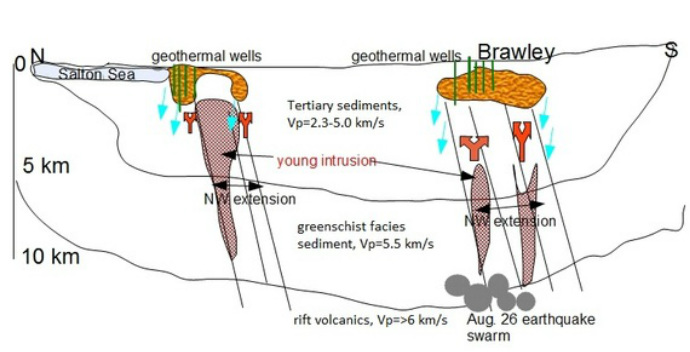
North south geologic cartoon through the Brawley fault zone with velocity structure, Aug. 26 quake swarm and geothermal systems.
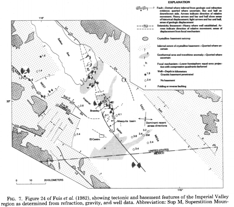
Seismic velocity structures in the Salton Sea area from refraction studies done after the Imperial 1979 earthquake. From: Fuis, G.S., Mooney, W.D., Healy, J.H., McMechan, G.A., and Lutter, W.J., 1982, Crustal
structure of the Imperial Valley region, in The Imperial Valley, California, earthquake of
October 15, 1979: U.S. Geological Survey Professional Paper 1254, p. 25-49.
Salton Trough Structure
copied from http://www.johnmartin.com/earthquakes/eqsafs/safs_835.htm
Quote:
The Salton Trough is the landward extension of a ridge/transform-fault system, the East Pacific Rise, of the Gulf of California (see Figure. 3.13). This system became well established during the late Cenozoic (approx 5 Ma) as the plate boundary jumped inland from offshore Baja California (Atwater, 1970, 1989; Humphreys and Weldon, in press).
The Salton Trough is underlain by upper Cenozoic sedimentary rocks and minor amounts of volcanic rocks, which are exposed chiefly around its edge and are penetrated in wells. Onset of rifting and major subsidence in the Salton Trough was followed by marine incursion during the latest Miocene to late(?) Pliocene, as indicated by the Imperial Formation (Dibblee, 1954; Powell, 1984). The thick Cenozoic sedimentary section 15 offset by Quaternary faults, both exposed and buried, and is intruded by Quaternary volcanic rocks, both silicic rocks that form volcanoes at the two inferred onshore spreading centers (Figure. 8.7) and mafic rocks that are penetrated in geothermal wells (Elders and others, 1972; Robinson and others, 1976). Faulting in the Salton Trough occurs primarily on conjugate northwest- and northeast-striking faults and is largely strike slip (Johnson and Hadley, 1976; Johnson, 1979; Fuis and others, 1982). North-south-striking faults, however, such as the north end of the Imperial fault, the Brawley fault, and north-south-striking seismicity lineaments (that outline inferred spreading centers; Figures. 8.1, 8.7), have normal components and lead to the subsidence that ultimately created the Salton Trough. Earthquake hypocentral depths indicate that brittle fault motion extends to about 12-km depth in the Imperial Valley but deeper in the adjacent Peninsular Ranges along the San Jacinto fault (Doser and Kanamori, 1986).
Detachment faulting on the east flank of the Salton Trough, in the Chocolate Mountains and other ranges, preceded the Pliocene and later basin-forming tectonics in the Salton Trough (Dillon, 1975; Berg and others, 1982; Frost and others, 1982). Similar faulting on the west flank of the Salton Trough, however, may have both preceded and overlapped in time the tectonics in the Salton Trough (Wallace and English, 1982; Schultejahn, 1984; Isaac and others, 1986).
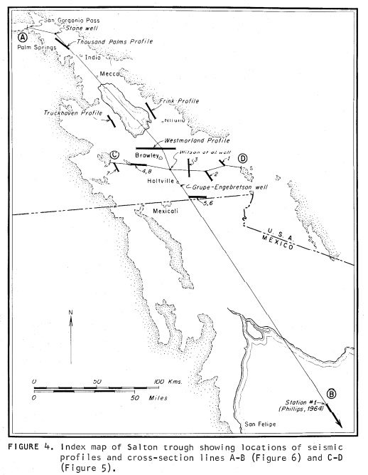
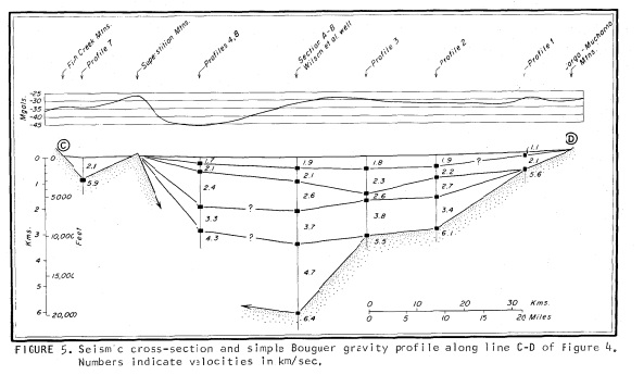
Biehler and others (1964) and Fuis and others (1982, 1984) demonstrated from seismic surveys that the sedimentary rocks (1.8-5.5 km/s) in the central Salton Trough are as much as 5 km thick (Figure. 8.6A). Below 5-km depth, a low-velocity (5.6 km/s) "basement," which is not separated from the overlying sedimentary rocks by a velocity discontinuity, is inferred to be metamorphosed (greenschist facies) sedimentary rocks (Fuis and others, 1982, 1984); this "basement" layer extends to 12-km depth. High heat flow in the Salton Trough (see Lachenbruch and others, 1985) is inferred to cause the metamorphism of the sedimentary rocks. Thus, the entire section of inferred upper Cenozoic sedimentary rocks, metamorphosed and unmetamorphosed, is as much as 12 km thick.
Below 12- to 14-km depth in the Salton Trough, a high-velocity (7.1-7.2 km/s) "subbasement" that is indicated by seismic-refraction data (Figure. 8.6A) is inferred to be gabbro generated at one of the nearby spreading centers (Fuis and others, 1982, 1984). Modeling of seismic-refraction and gravity data indicate that the Moho in the central Salton Trough is 23 to 28 km deep (Fuis and others, 1982, 1984). The central Salton Trough is interpreted to be underlain entirely by late Cenozoic crust (Figure. 8.6B).
Buried scarps separating old crust (plutonic and metamorphic rocks; 5.9-6.0 km/s) from new crust (sedimentary and basaltic rocks; 1.8-7.2 km/s) are visible by seismic methods on both sides of the Salton Trough (Fuis and others, 1982; Fuis and Kohler, 1984). On the west side of the rift, where the new-crust/old-crust boundary is ragged in outline (Figure. 8.7), we interpret normal faults (Figure. 8.6B); on the east side, where this boundary 15 linear, we interpret a strike-slip fault. In our cross section, faults on the west side of the Salton Trough are inferred to have originated by pullaway from the Cerro Prieto spreading center to the southeast; the fault on the east side is inferred to be a largely passive suture (Figures. 8.6B, 8.7; Fuis and others, 1982). A similar rift configuration is seen, for example, in the Gulf of Elat (Gulf of Aqaba, Red Sea; Ben-Avraham, 1985).
Copied from CVO website:
From: Robinson, Elders, and Muffler, 1976, Quaternary volcanism in the Salton Sea geothermal field, Imperial Valley, California: GSA Bulletin 87, p.347-360, March 1976
The Salton Sea geothermal field lies in the Salton Trough, the landward extension of the Gulf of California, an area of active crustal spreading. Surface volcanic rocks of the field consist of five small rhyolite domes extruded onto Quaternary sediments of the Colorado River delta. Two domes are linked by subaqueous pyroclastic deposits; the others are single extrusions with or without marginal lava flows. The domes are low-calcium, alkali rhyolite with 1 to 2 percent crystals. Similar silicic rocks found in wells have been extensively altered by geothermal brines. ...
Many recent studies (Wilson, 1965; Atwater, 1970; Larson and others, 1972; Moore, 1973) have suggested that the Gulf of California is the locus of a spreading ridge along which the Pacific Plate is being rifted away from the North American Plate at a rate of perhaps as much as 6 centimeters per year (Larson, 1972). ...
The (Salton Buttes) volcanoes lie within the Salton Sea geothermal field where temperatures measured in wells drilled for geothermal brines range up to 360 degrees C at depths of 1,500 to 2,500 meters (Helgeson, 1968). The wells produce a hot brine containing up to 160,000 ppm of dissolved solids, chiefly Cl, Na, K, Ca, and Fe (White, 1968). Under the influence of this hot saline brine, the sediments of the Salton Trough are being transformed into metamorphic rocks of the greenschist facies (Muffler and White, 1969). ...
The Salton Buttes are four small volcanoes designated from southwest to northeast as Obsidian Butte, Rock Hill, Red Island, and Mullet Island. Red Island is composed of two domes linked by a deposit of subaqueous pyroclastic material; the other volcanoes are single domal extrusions with or without marginal lava flows. The domes are spaced at intervals of 2 to 3 kilometers along a northeast trend. ...
Obsidian Butte consists of a central dome of rhyolite surrounded on all sides by a single rhyolite flow. The dome is approximately 250 meters in diameter and rises some 30 meters above the adjacent alluvial surface of the Imperial Valley. The flow stands 20 to 25 meters below the crest of the central dome. The contact between the flow and the dome is exposed on the northwest side of the dome as a steeply dipping breccia zone. The central dome of Obsidian Butte is composed of medium-gray to dark-gray rhyolite that is locally pumiceous and (or) spherulitic. Flow foliation, although variable and erratic in detail, defines a crudely domal pattern. The flow around Obsidian Butte consists of rhyolitic obsidian covered by a discontinuous mantle of brown-weathering, light-gray pumice. Numerous spines of black obsidian protrude upward and through the blocky pumice mantle. Low ridges and troughs rudely concentric to the central dome indicate that the flow spread radially from a vent located where the dome now rises. At the perimeter of this flow, there is a discontinuous ring of ten obsidian hills that rise as much as 15 meters above the surrounding alluvium. ...
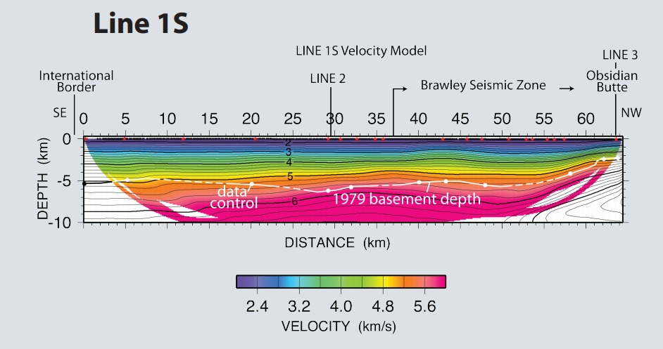
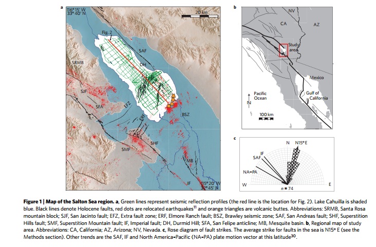
Preliminary velocity model from NS profile through the Imperial Valley, BSZ area, from the SSIP project as described by Fuis, et al, 2011 http://earthquake.usgs.gov/research/structure/salton/IRIS_poster_2012-11.pdf
As shown by the dashed line, the new refraction seismic model agrees reasonably well with the 1979 model shown above.
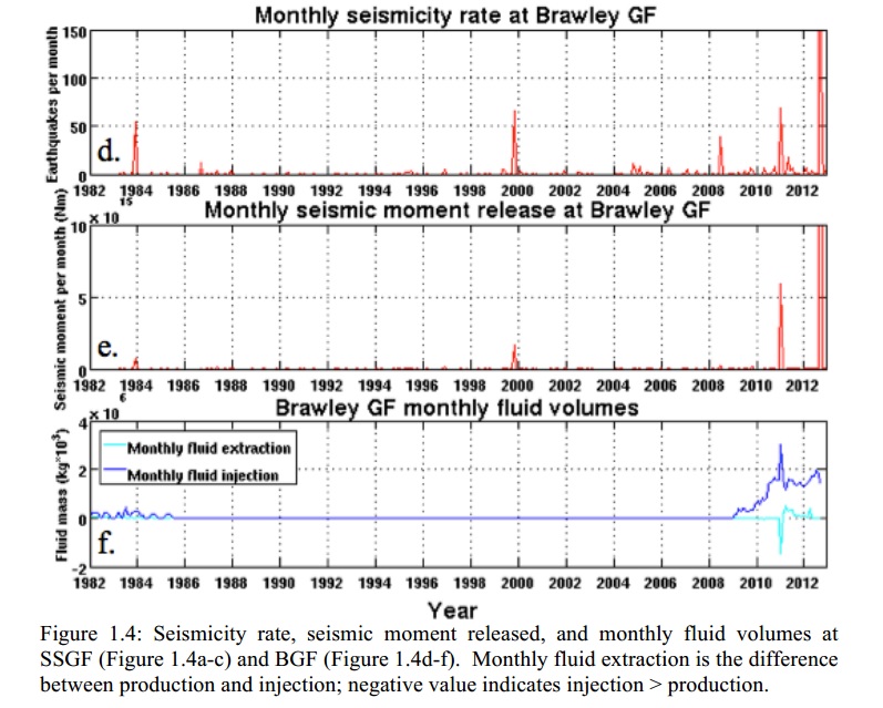
The thesis completed by Lajoie (2012) outlines the data which clearly show that pumping and extraction at the geothermal field NW of Brawley are directly correlated with the 2012 seismicity episode which is not surprising when the well field pattern is matched to the seismicity pattern.
References
Biehler, Shawn, 1964, Geophysical study of the Salton Trough of southern California: Ph. D. Thesis at Cal. Inst. of Tech., Pasadena, CA.
http://thesis.library.caltech.edu/4077/1/Biehler_s_1964.pdf old refraction model but good
Brophy, P., Lippman, M. J, Dobson, P. F., and Poux, B., 2010, The Geysers Geothermal Field Up[date 1990-2010 Special Report No. 20: Geothermal Resources Council.
http://www.osti.gov/bridge/servlets/purl/1048267/1048267.PDF(GRC report on geysers)
California Unions for Reliable Energy (CURE) vs ORMAT suit
09-08_CUREs_Letter_to_Charlene_Wardlow_Data_Request_Set_01_TN-62114.pdf suit against ORMAT
Chen, X. and Shearer, P. M., 2011, Comprehensive analysis of earthquake source spectra and swarms in the Salton Trough, California: Journ. Geophys. Res., v. 116, B09309, 17 pp.
http://www.agu.org/pubs/crossref/2011/2011JB008263.shtml stress drops in the Salton Sea earthquakes
Dorsey, R. J., and Umhoefer, P. J., 2012, Influence of sediment input and plate-motion obliquity on basin development along an active oblique-divergent plate boundary: Gulf of Californai and Salton Trough: Chapter 10, Sediment Input and Plate-Motion Obliquity. http://pages.uoregon.edu/rdorsey/Downloads/Dorsey&Umhoefer2012.pdf
Doser, D. I. and Kanamori, Hiroo, 1986, Depth of seismicity in the Imperial Valley region (1977-1983) and its relationship to heat flow, crustal structure and the October 15, 1979, earthquake: Journ. Geophys. Res., v. 91, B1, p. 675-688.
http://www.gps.caltech.edu/uploads/File/People/kanamori/HKjgr86b.pdf Dozier and Kanamori study of 1979 earthquake
http://www.energy.ca.gov/proceedings/11-cai-02/documents/cure/2011-09-08
Hudnut, K. W., Seeber, L., and Pacheco, J., 1989, Cross-fault triggering in the November 1987 Superstition Hills earthquake sequence, southern California: Geophysical Research Letters, v. 16, no. 2, p. 199-202
HEATON, Thomas G., JOHN G. ANDERSON, AND PETER T. GERMAN
Bulletin of the Seismological Society of America, Vol. 73, No. 4, pp. 1161-117l, August 1983
G R O U N D F A I L U R E ALONG T H E N E W R I V E R C A U S E D BY T H E
O C T O B E R 1979 I M P E R I A L VALLEY E A R T H Q U A K E S E Q U E N C E
Hole, John, Stock, Joann, Fuis, Gary, Rymer, M., and Gonzalez-Fernandez, A., 2012, The Salton Seismic Imaging Project (SSIP), Rift Processes and Earthquake Hazards in the Salton Trough: EarthScope Project Outline at www.earthscope.org.
http://www.earthscope.org/es_doc/meetings/WESP/WedPM/Hole-Salton-EScopeSciencePlan09.pdf
Klose, C. D., 2011, Human-Triggered earthquakes and their immacts on human security: Nature Proceedings.
http://precedings.nature.com/documents/4745/version/3/files/npre20104745-3.pdf Christian Klose paper on triggered earthquakes
Lajoie, Lia Joyce, 2012, Seismic response to fluid injection and production in two Salton Trough geothermal fields, southern California:M.S., Earth Science UC Santa Cruz.
Peter Lovely, John H. Shaw, Qinya Liu, and Jeroen Tromp, 2006, A Structural VP Model of the Salton Trough, California, and Its Implications for Seismic Hazard: Bulletin of the Seismological Society of America, Vol. 96, No. 5, pp. 1882–1896.
http://www.gps.caltech.edu/classes/ge111/Papers/Lovely.BSSA.pdf VP model of salton trough
Stanley, Stanley, W.D., Rodrigues B.D., and Benz H.M., 1995. A Revised Tectonic Model for The Geysers‐ Clear Lake Geothermal Region California. In: Proceedings of the World Geothermal Congress, Florence Italy, pp. 1193‐1198.
http://www.osti.gov/bridge/servlets/purl/1048267/1048267.PDF
Wisian, K. W., 2000, INSIGHTS INTO EXTENSIONAL GEOTHERMAL SYSTEMS FROM NUMERICAL MODELING: Proceedings of the World Geothermal Congress 2000, Kyushu-Tohoku, Japan, p. 1946-1952.
http://www.geothermal-energy.org/pdf/IGAstandard/WGC/2000/R0572.PDF numerical models of extensional geothermal systems
http://response.scec.org/comments/recent scec forum comments
Zachariasen, Judith and Sieh, Kerry, The transfer of slip between two en echelon strike-sli faults: A case study from the 1992 Landers earthquake, southern California: Jour. Geophys. Res., v. 100, B8, p. 15,281-15,301. http://www.gps.caltech.edu/~sieh/pubs_docs/papers/P95c.pdf
LIST OF INFORMAL RESEARCH WEB SITES
Western Washington Tectonics and Faults
http://pugetlowlandseismicity.weebly.com
2014 Oso, Wa Landslide
http://ososlide.weebly.com
brawleyquakes
http://brawleyquakes.weebly.com
cascadiageophysics
http://www.cascadiageophysics.com
imishmashStHelens
http://imishmashsthelens.weebly.com
Tectonic Background for Washington State Earthquakes
http://tremorandtectonicswashington.weebly.com